Using multi-temporal remote sensing data to quantify forest cover change in Dien Bien Dong district, Dien Bien province during 1991-2017
Quantifying temporal changes of land use and land cover (LULC), in particular forest covers from satellite images at the various scales has been conducted in Vietnam for several years. However, a few studies have carried out to investigate LULC in Dien Bien Dong district. Hence, using multi-Temporal remote sensing data to quantify LULC changes was conducted in Dien Bien Dong district, Dien Bien province during 1991 - 2017. In this study, Landsat data, including Landsat 5 (TM) in 1991, 1999 and 2009, and Landsat 8 (OLI) for 2017 with spatial resolution of 30 m was used to quantify the spatial changes of forest cover exents and then defined the drivers of changes. NDVI (Normalized Difference Vegetation Index) in combination with unsupervised classification was used. As a result showed that there was a change in forest cover extents from 1991 to 2017. Accuracy assessments of classified forest cover maps indicated that there was relatively high accurate with over 85.0%. In particular, forest cover extents declined in the period of 1991 - 2017 from 49,351.7 ha to 37,414.6 ha (decreased by 11,937.1 ha). Forest cover extents decreased by 1,683.7 ha, 9,268.7 ha and 984.6 ha in the period of 1991 - 1999, 1999 - 2009 and 2009 - 2017, respectively. Main drivers of forest cover extents were due to human forces, such as slash and burning, shifting cultivation
Trang 1
Trang 2
Trang 3
Trang 4
Trang 5
Trang 6
Trang 7
Trang 8
Trang 9
Tóm tắt nội dung tài liệu: Using multi-temporal remote sensing data to quantify forest cover change in Dien Bien Dong district, Dien Bien province during 1991-2017
tents from 1991 - 2017 (ha)
 Year
 Land covers
 1991 1999 2009 2017
 Forest 49,351.7 47,668.0 38,399.2 37,414.6
 Non-forest 70,760.3 72,444.0 81,712.7 82,697.3
 Total 120,111.9 120,112.0 120,111.9 120,111.9
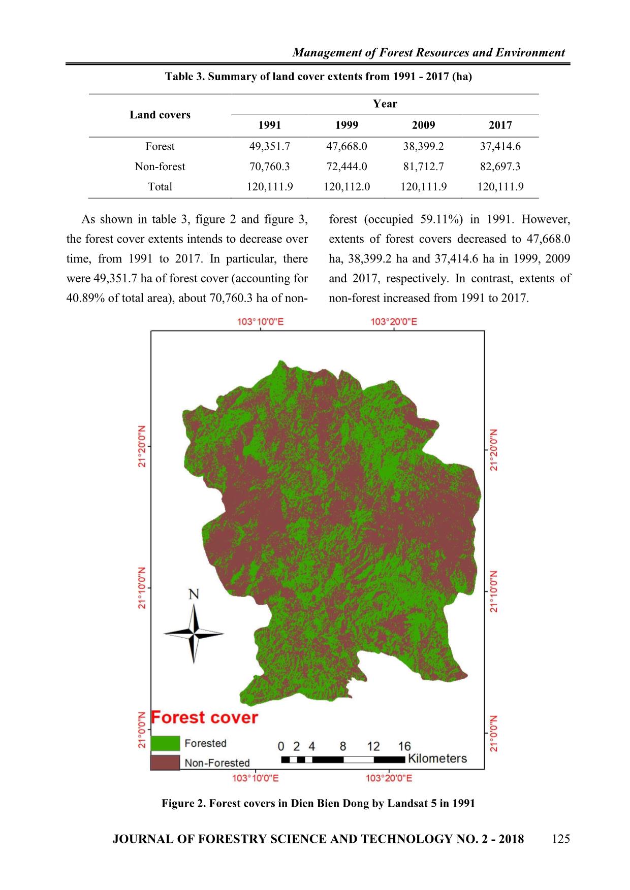
 As shown in table 3, figure 2 and figure 3, forest (occupied 59.11%) in 1991. However,
the forest cover extents intends to decrease over extents of forest covers decreased to 47,668.0
time, from 1991 to 2017. In particular, there ha, 38,399.2 ha and 37,414.6 ha in 1999, 2009
were 49,351.7 ha of forest cover (accounting for and 2017, respectively. In contrast, extents of
40.89% of total area), about 70,760.3 ha of non- non-forest increased from 1991 to 2017.
 Figure 2. Forest covers in Dien Bien Dong by Landsat 5 in 1991
 JOURNAL OF FORESTRY SCIENCE AND TECHNOLOGY NO. 2 - 2018 125
 Management of Forest Resources and Environment
 Figure 3. Forest covers in Dien Bien Dong by Landsat 8 in 2017
 Accuracy assessments of LULC classification survey in 2017 and additional information
 For accuracy assessments of image from Google Earth in 1991, 1999 and 2009
classification, ground control points from field were used. As a result showed in table 4.
 Table 4. Summary of accuracy assessments of forest cover maps in selected years
 Year Classes Forest Non-forest Total Accuracy (%)
 Forest 78 5 90 86.7
 1991 Non-forest 3 74 80 92.5
 Total 40 43 170 89.4
 Forest 80 10 90 88.9
 1999 Non-forest 5 72 80 90.0
 Total 42 51 170 89.4
 Forest 76 14 90 84.4
 2009 Non-forest 11 69 80 86.3
 Total 38 66 170 85.3
 Forest 112 8 120 93.3
 2017 Non-forest 6 94 100 94.0
 Total 118 102 220 93.6
126 JOURNAL OF FORESTRY SCIENCE AND TECHNOLOGY NO. 2 - 2018
 Management of Forest Resources and Environment
 As shown in table 4, by using NDVI confusions between forest covers and non-
classification in combination with forest covers during assessments conducted.
unsupervised classification, maps of forest The errors may be due to the spectral
covers in four selected years are at high disturbance of the image, the effect of the
accuracy. In particular, the accuracies of forest angle of the image, the shade of the terrain
covers mapping are at 89.4%, 89.4%, 85.3% cannot be eliminated in the process of image
and 93.7% in 1991, 1999, 2009 and 2017, processing.
respectively. With these results, using the 3.2. Spatial forest cover change and drivers
NDVI in combination with the unsupervised of change
classification is reasonable for forest covers Based on the maps of forest covers, study
mapping in Dien Bien Dong due to the spatially quantified changes in forest covers in
relatively high accuracy. Besides, there are still selected periods as shown in table 5.
 Table 5. Forest cover change detection in selected periods
 Types
 Years Forest Net change
 No forest Forest loss Forest gain
 stable detection
 1991 - 1999 57207.3 15236.6 13552.9 34115.0 -1683.7
 1999 - 2009 62450.2 19262.5 9993.8 28405.4 -9268.7
 2009 - 2017 63026.3 19671.0 18686.4 18728.2 -984.6
 As shown in table 5, forest covers lost are forest covers in net change detection during the
detected in net change of all three selected period of 1991 - 1999, 1999 - 2009 and 2009 -
periods. These findings indicate that there have 2017, respectively. It is also notable that period
been a negative change in forest covers in Dien of 1999 - 2009 with largest forest cover extents
Bien Dong district. In particular, there were a was lost compared with other periods.
loss of 1683.7 ha, 9298.7 ha and 984.6 ha of
 Figure 4. Forest covers change in the period of 1991 - 2017
 JOURNAL OF FORESTRY SCIENCE AND TECHNOLOGY NO. 2 - 2018 127
 Management of Forest Resources and Environment
 Drivers of Forest cover change in kept the forest covers extents of Dien Bien
selected periods Dong reducing. According to Mr. Nguyen
 Period of 1991 - 1999: In this period, Dien Trong Muoi, Deputy Director of Dien Bien
Bien Dong district was just newly established Dong District Forest Protection Department
and management broad was under the (Personal communication, 2017), in recent
arrangement with a lack of professional and years, the number of violations of the Law on
skilled staff management. In addition, more Forest Protection and Development has
than 90% of the population were ethnic increased. In 2015, forest rangers discovered,
minorities with nearly 50% of poor prosecuted and fired with over 70 million
households, limited intellectual level and low VND. Of which, 6 cases of deforestation with
rate of socio-economic growth additionaly the area of forest cleared over 20 ha were
contributed to make situation much worse. The caught, mainly protection forests and
main economic activities of the local people productive forests. Forest fires is also a
included shifting cultivation, which was continuous occurrence. In the first six months
dependent on upland fields. In addition, there of 2016, there were 17 cases of forest fires
were netheir programs nor projects applied to and 182 ha of forests were destroyed by fires.
encourange local people to participate in forest However, this period, the loss of forest cover
protection. Therefore, some areas of the forests extents was less than 2009, because in this
were cleared simply for cultivating crops and period the management broad have applied
improving local livelihoods. some big projects, such as forest and land
 Period of 1999 - 2009: This period was allocation, forest plantation and financial
featured with extremely difficult economic support from Payments for ecosystem services
conditions together with poor infrastructure program.
system. There was a tendency of ethnic 3.3. Solutions for sustainable forest
people’s migration for shifting cultivation management
after only 2 to 3 years of cultivation when the Based on the findings identified in Dien
upland rice was degraded, eroded and washed Bien Dong, including poor infrastructure,
away by water, land was unable to be many poor ethnic minorities with low
cultivated. Consequently, leaving behind the awareness, lack of staff management,
wilderness, the villagers continued to cut ineffective management plans. The study
down the forest to make slash and burning. purposes some key solutions for sustainable
Local people did not realized the importance forest management in Dien Bien Dong district,
of forest resources and when slash and these include:
burning activities led to occurrence of forest Lack of human resources: A number and
fires more often. This could explains why the quality of forest managers should be increased
largest forest cover extents were lost in this and improved by providing more training
period. courses and workshops to enrich the required
 Period of 2009 - 2017: In this period, the knowledge for natural resources management in
area of forest continuously decreased because the area.
of increasing growth rate of population, Effective forest management plans:
leading to increasing demand for forest Enhancing measures in the forest management,
resources. Along with that, the illegal forest protection and development should be prioritised
exploitation, deforestation and forest fires have with focusing on the prevention and control of
128 JOURNAL OF FORESTRY SCIENCE AND TECHNOLOGY NO. 2 - 2018
 Management of Forest Resources and Environment
forest fires in dry season. Promoting there are a high accuracy in all selected
dissemination of measures in the management, years, over 85.0% of map accuracy. The
protection and development of forests to results show forest cover extents declined
agencies, departments, unions, communes, towns from 37,414.6 ha in the period of 1991 -1999
in the district also should be paid into attention. and 9,268.7 ha in the period of 1999 - 2009
 Improvement of local livelihoods: and 984.6 ha in the period of 2009 - 2017.
Intensive development in agroforestry and The study has also conducted the interview
agricultural cultivation techniques should be and information obtained from document
carried out to contribute to increasing products materials indicated that human is the main
and incomes of local people. driving forces of forest cover change rather
 Public media enhancement: Raising local than natural factors. The main human drivers
awareness of the important roles and benefits of of forest cover change included shifting
forest should be carried out. Encouraging local cultivation, depending on upland fields and illegal
people to plant and protect forests, use natural logging, main contribution of natural induced
resources in a sustainable way should be taken (forest five some time by human), landslide and
into account as designing land use planning. erosion. The study also found that Dien Bien
 Enhancement of scientific research: Dong is a poor district, with low economic
Promoting scientific research in the area, conditions, poor infrastructure and have many
including on monitoring and management ethnic groups with low education. Therefore,
forest resources should be prioritised. The management plans should be combined
scientific researches would help policy makers between sustainable use of resources and local
to drive reasonal decisions on sustainable livelihood improvements in combination with
forest development and planning. certain local conditions.
 Enhancement of forest policies: Land and ACKNOWLEDGEMENT
forest allocation to individual households and We would like to express our gratitude to
communities under 30a/2008/NQ-CP of the staffs and local authorities in Dien Bien
Government should be reviewed and revised. Dong for the enthusiastic support during our
In addition, Land and forest land allocation works conducted as well as and special thanks
under the Plan No. 388/KH-UBND dated to local people for supporting us to collect
20/02/2013 was issued by Dien Bien data.
Provincial People's Committee should be REFERENCES
revised to complete procedures for allocation 1. Al-Hassideh, A., Bill, R. (2008). Land cover
of land, forest, granting forestry land use right changes in the region of rostock - can remote sensing
 and gis help to verify and consolidate official census
certificates to individuals and organizations, in
 data? The International Archives of the
particular strictly dealling with violations of Photogrammetry, Remote Sensing and Spatial
the Law on Forest Protection and Information Sciences. Vol. XXXVII. Part B8. Beijing
Development. 2008, pp. 27-33.
IV. CONCLUSION 2. Hathout, S. (2002). The use of GIS for monitoring
 and predicting urban growth in East and West St Paul,
 This study has successfully constructed
 Winnipeg, Manitoba, Canada. Journal of Environmental
the status of land cover maps in 1991, 1999, Management, 66: 229-238.
2009 and 2017 and maps of forest covers 3. Homer, C., Dewitz, J., Fry, J., Coan, M., Hossain,
change in three periods of 1991 - 1999, 1999 N., Larson, C., Herold, N., McKerrow, A., Vandriel, J.
- 2009 and 2009 - 2017. As result shown that N., Wickham, J. (2007). Completion of the 2001
 JOURNAL OF FORESTRY SCIENCE AND TECHNOLOGY NO. 2 - 2018 129
 Management of Forest Resources and Environment
National Land Cover Database for the Conterminous data to determine land use changes in Datong basin,
United States. Photogrammetric Engineering and China. Environmental Geology, 57: 1825-1837.
Remote Sensing, 73: 337-341. 8. Tran Thu Ha, Phung Minh Tam, Pham Thanh
 4. Kass, G., Kempka, D., Lackey, L. (1994). Using Que, Le Thi Giang (2016). Integrated GIS and remote
Remote Sensing to Detect and Monitor Land-Cover and sensing to monitoring forest change in area of Cao
Land-Use Ghang. Photogrammetric Engineering & Phong district, Hoa Binh province during 2005 - 2015.
Remote Sensing, Vol. 60, No. 3, March 1994, pp. 331-33. Journal of Forest Science and Technology, No. 4/2016.
 5. Kauth, R.J., Thomas, G.S. (1976). The Tasselled 9. Wulder, M.A., White, J.C., Goward, S.N., Masek,
Cap- A Graphic Description of the Spectral-Temporal J.G., Irons, J.R., Herold, M., Cohen, W.B., Loveland,
Development of Agricultural Crops as Seen by T.R., Woodcock, C.E. (2008). Landsat continuity: Issues
LANDSAT. Purdue University. and opportunities for land cover monitoring. Remote
 6. Lent, J.D., Thorley, G.A. (1969). Some Sensing of Environment, 112: 955-969.
observations on the use of multiband spectral 10. Zhu, Z., Woodcock, C.E. (2014). Continuous
reconnaissance for the inventory of wildland resources. change detection and classification of land cover using
Remote Sensing of Environment, 1: 31-45. all available Landsat data. Remote sensing of
 7. Sun, Z., Ma, R., Wang, Y. (2009). Using Landsat Environment, 144: 152-171.
 SỬ DỤNG DỮ LIỆU VIỄN THÁM ĐA THỜI GIAN ĐỊNH LƯỢNG THAY ĐỔI
 ĐỘ CHE PHỦ RỪNG TẠI HUYỆN ĐIỆN BIÊN ĐÔNG,
 TỈNH ĐIỆN BIÊN GIAI ĐOẠN 1991 - 2017
 Lò Hồng Sơn1, Nguyễn Hải Hòa2, Diana Gabriela Flores Montenegro3,
 Nguyễn Thị Thu Hiền4, Đặng Hoàng Vương5, Nguyễn Thị Bích Hảo6
 1,2,5,6Trường Đại học Lâm nghiệp
 3Trường Đại học Gabriel Rene Moreno
 4Trường Đại học Nông Lâm - Đại học Thái Nguyên
 TÓM TẮT
 Nghiên cứu về sự thay đổi độ che phủ của rừng và sử dụng đất theo thời gian thông qua việc sử dụng các tư
 liệu viễn thám trên nhiều quy mô khác nhau đã được tiến hành ở Việt Nam trong những năm trở lại đây. Tuy
 nhiên, có rất ít nghiên cứu được áp dụng để điều tra việc sử dụng đất và thay đổi độ che phủ đất hay sự thay đổi
 độ che phủ của rừng tại huyện Điện Biên Đông. Do vậy, nghiên cứu sử dụng dữ liệu viễn thám đa thời gian để
 định lượng việc thay đổi độ che phủ của rừng và xác định các nguyên nhân tác động đến sự thay đổi độ che phủ
 tại huyện Điện Biên Đông, tỉnh Điện Biên trong giai đoạn 1991 - 2017 được thực hiện. Trong nghiên cứu này,
 chúng tôi sử dụng dữ liệu hình ảnh vệ tinh, Landsat 5 (TM) cho các năm 1991, 1999, 2009 và Landsat 8 (OLI)
 năm 2017 với độ phân giải không gian 30 m. Chỉ số NDVI (chỉ số khác biệt thực vật được chuẩn hóa) kết hợp
 với phương pháp phân loại không kiểm định được sử dụng. Kết quả nghiên cứu cho thấy độ chính xác của các
 bản độ che phủ rừng sau phân loại đạt trên 85,0%. Với kết quả này có thể nói phương pháp kết hợp NDVI và
 phân loại không kiểm định là phù hợp và có thể sử dụng cho khu vực nghiên cứu. Kết quả cho thấy độ che phủ
 rừng giảm trong giai đoạn 1991 - 2017 từ 49.351,68 ha xuống còn 37.414,62 ha (giảm 11.937,06 ha), giai
 đoạn 1991 - 1999 giảm 1.683,72 ha, giảm 9.268,74 ha giai đoạn 1999 - 2009 và giảm 984,6 ha giai đoạn
 2009 - 2017.
 Từ khóa: Điện Biên Đông, GIS, sử dụng đất, thay đổi che phủ đất, viễn thám.
 Received : 27/02/2018
 Revised : 23/3/2018
 Accepted : 02/4/2018
 130 JOURNAL OF FORESTRY SCIENCE AND TECHNOLOGY NO. 2 - 2018
File đính kèm:
 using_multi_temporal_remote_sensing_data_to_quantify_forest.pdf

