Characteristics of fuels and fire risk among the main forest types in Hoang Lien National Park
Hoang Lien National Park has 25,113.66 ha of forest under its management, including the main forest types as natural broadleaf evergreen forest (poor; average and rehabilitation forests), bamboo, bamboo and mixed forests, and plantation forest. There are small areas of natural rich forest left, mainly located in strictly protected zone, and 2,143.75 ha of uncovered land or area of regenerating woody plants. There are clear differences in terms of fuels among forest types that were clarified by using indicators as trunk height, height and cover of understory vegetation, load and moisture of fuels. From the characteristics of fuels, the study divided fire risk for forests, shrublands and grasslands into 4 levels of danger. As a result, shrubs and grasses and bamboo forest are at highest fire risk (level IV); Plantation forest and evergreen poor forest are at high risk of fire (level III); Rehabilitation forests are at medium risk (level II); and evergreen average and rich forests are at low risk (level I). From the results above, this study also has created a map of fire risk division for forest types in Hoang Lien National Park
Trang 1
Trang 2
Trang 3
Trang 4
Trang 5
Trang 6
Trang 7
Trang 8
Trang 9
Trang 10
Tải về để xem bản đầy đủ
Tóm tắt nội dung tài liệu: Characteristics of fuels and fire risk among the main forest types in Hoang Lien National Park
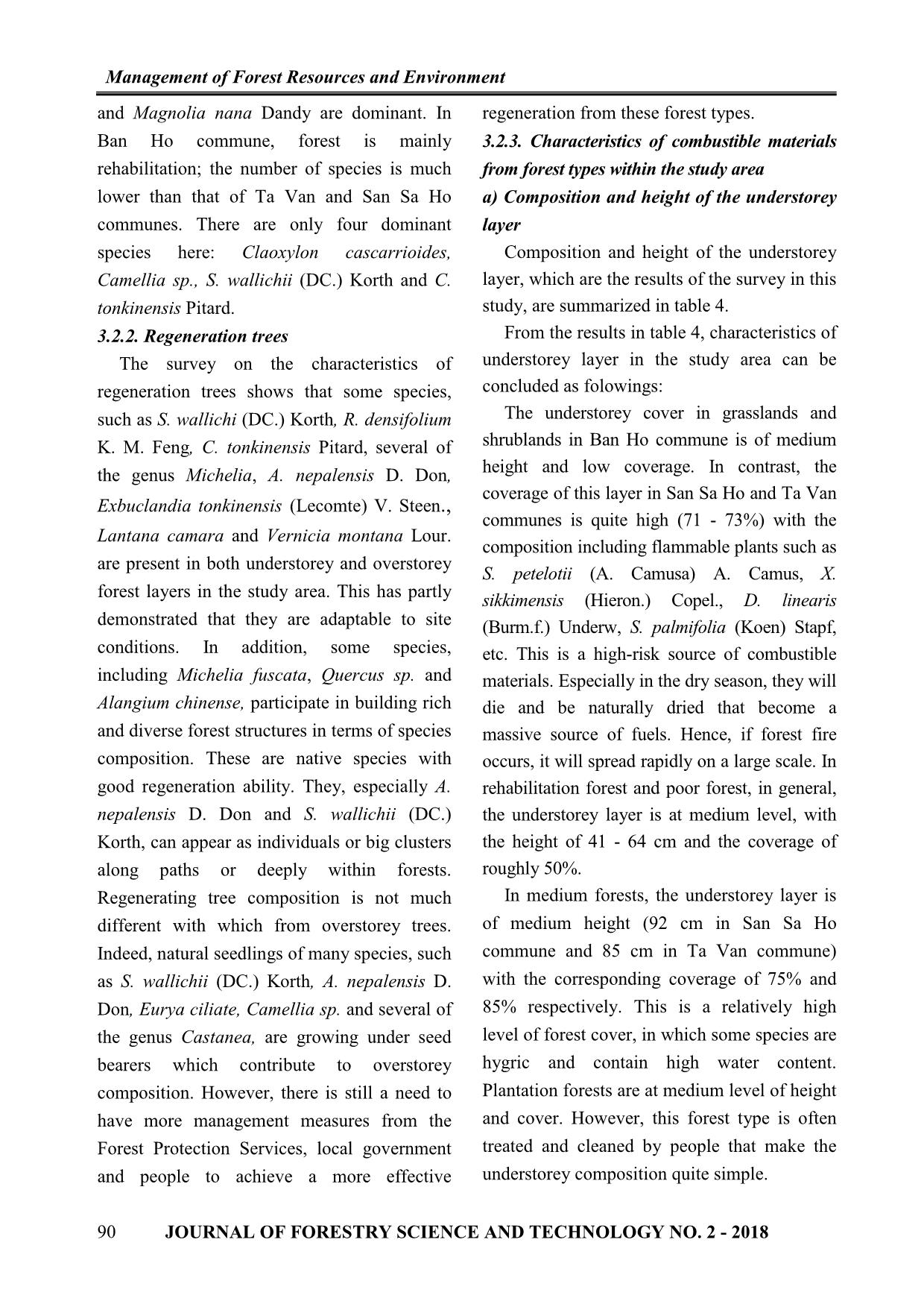
on.) Copel., S. palmifolia (Koen) Stapf,
 Poor forest 41 49
 Dicranopteris linearis (Burm.f.) Underw., Bidens pilasa
 San Sa Ho L., Rubus Alceaefolius Poir., Physalis angulata.
 X. sikkimensis (Hieron.) Copel., D. linearis (Burm.f.)
 Underw., S. palmifolia (Koen) Stapf, Pogonatherium
 Rehabilitati
 crinitum (Thunb.) Kunth, Herminium lanceum (Thunb. ex 45 45
 on forest
 Sw.) Vuijk., R. Alceaefolius Poir., S. petelotii (A. Camusa)
 A. Camus, P, angulata, Chromalaena odorata (L.).
 S. palmifolia (Koen) Stapf, X. sikkimensis (Hieron.) Copel.,
 Dysoxylum tonkinense Chev. ex Pellegr., R. Alceaefolius
 Medium
 Poir. (R. moluccanus L), Tradescantia pallida, Psychotria 92 75
 forest
 rubra (Lour.) Poir (P. reevesii Wall), M. imbricata Wall. ex
 C.B. Clarke, Phrynium placentarium...
 X. sikkimensis (Hieron.) Copel., Dicranopteris linearis
 Plantation
 (Burm.f.) Underw., Setaria palmifolia (Koen) Stapf, R. 67 60
 forest
 Alceaefolius Poir., C. odorata (L.).
 S. petelotii (A. Camusa) A. Camus, P. angulata, S.
 Grassland, palmifolia (Koen) Stapf, M. imbricata Wall. ex C.B.
 49 71
 shrubland Clarke, D. linearis (Burm.f.) Underw., X. sikkimensis
 (Hieron.) Copel
 D. linearis (Burm.f.) Underw., C. odorata (L.), M.
 imbricata Wall. ex C.B. Clarke, Piper chaudocanum C.
 Poor forest 64 41
 DC, R. Alceaefolius Poir., S. palmifolia (Koen) Stapf, X.
 sikkimensis (Hieron.) Copel., P. angulata...
 S. palmifolia (Koen) Stapf, Setaria glauca (L.) P.
 Beauv., X. sikkimensis (Hieron.) Copel., M. imbricata
 Rehabilitati
 Wall. ex C.B. Clarke, D. linearis (Burm.f.) Underw., 41 53
 Ta Van on forest
 P. angulata, Amomum aromaticum Roxb., R.
 Alceaefolius Poir. (R.moluccanus L)...
 X. sikkimensis (Hieron.) Copel., S. palmifolia (Koen) Stapf,
 Medium
 M. imbricata Wall. ex C.B. Clarke, D. linearis (Burm.f.) 85 55
 forest
 Underw., Psychotria rubra (Lour.), A. aromaticum Roxb.
 S. petelotii (A. Camusa) A. Camus, Bamboo, S.
 Bamboo
 palmifolia (Koen) Stapf, Amomum lacteum Ridl., D. 85 80
 forest
 linearis (Burm.f.) Underw., Phrynium placentarium
 Setaria palmifolia (Koen) Stapf, X. sikkimensis
 Plantation
 (Hieron.) Copel., R. Alceaefolius Poir. (R. moluccanus 69 53
 forest
 L), A. aromaticum Roxb.
 Calamus sp., Maesa SP., X. sikkimensis (Hieron.)
 Rehabilitati Copel., S. palmifolia (Koen) Stapf, M. imbricata Wall.
 32 45
 on forest ex C.B. Clarke, Clerodendron infortunatum L,
 Dysoxylum tonkinense Chev. ex Pellegr....
 Ban Ho
 Sinobambusa sat (Bal.) T.Q. Nguyen Lau, Setaria
 Grassland, palmifolia (Koen) Stapf, X. sikkimensis (Hieron.)
 25 30
 shrubland Copel., Achyranthes aspera L., Bidens pilasa L., S.
 petelotii (A. Camusa) A. Camus
 JOURNAL OF FORESTRY SCIENCE AND TECHNOLOGY NO. 2 - 2018 91
 Management of Forest Resources and Environment
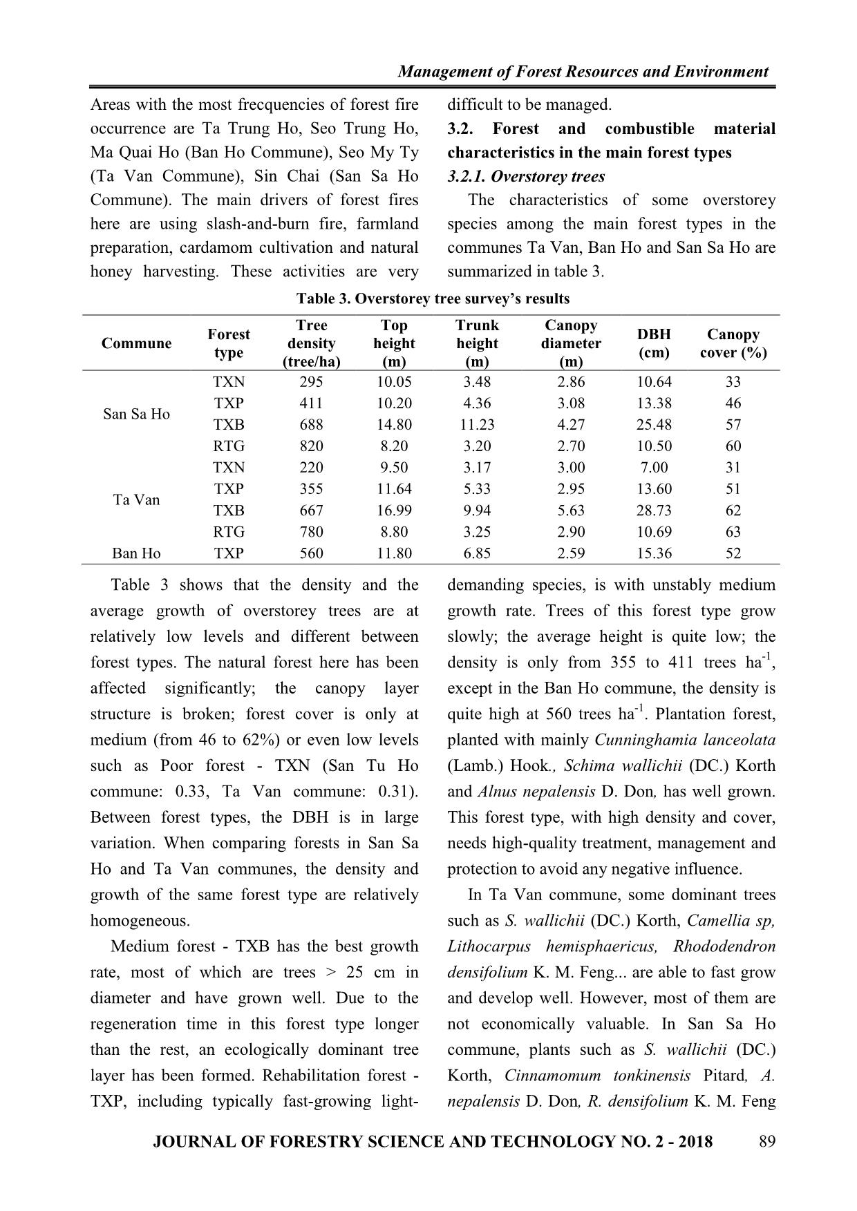
b) Mass and water content of fuels from of its direct effects on the flammable ability,
forest types emergence and spread speed of forest fires as
 Mass and water content (relative moisture well as the level of damage caused by the fires.
content) of fuels is a significant factor because These characteristics are in table 5.
 Table 5. Mass and water content of fuels from forest types
 Mass (tons/ha )
 Water content
 Commune Forest type Dried Green
 Total (%)
 material material
 Grassland, shrubland 11.21 11.31 22.52 13.33
 Poor forest 8.74 10.93 19.67 23.10
 San Sa Ho Rehabilitation forest 11.04 8.49 19.53 21.31
 Medium forest 13.99 3.02 17.01 30.41
 Plantation forest 13.24 6.43 19.67 22.23
 Grassland, shrubland 11.49 13.10 24.59 14.47
 Poor forest 7.11 13.30 20.41 21.37
 Rehabilitation forest 7.35 12.04 19.39 25.66
 Ta Van
 Medium forest 6.52 21.61 28.13 32.63
 Bamboo forest 6.50 8.72 15.22 16.73
 Plantation forest 13.56 6.98 20.54 24.09
 Rehabilitation forest 7.52 11.32 18.84 20.65
 Ban Ho
 Grassland, shrubland 10.75 12.24 22.99 15.43
 The results show that water content is quite located in a lower-elevation area or people
high in medium forests (30.41% in San Sa Ho have planted Amomum aromaticum Roxb.
commune and 32.63% in Ta Van commune). under the canopy that decrease fire risk to the
This may be caused by high canopy cover. The medium level. Indeed, A. aromaticum Roxb. is
canopy layer is capable of partly blocking solar a broad-crown plant that can cover the soil and
radiations along with the ability of water save water to hold fuel moisture at a moderate
retaining that make combustible materials on level.
the ground always of certain moisture. In Table 5 shows that there is a massive
rehabilitation and poor forests, the content of amount of combustible materials among forest
water in fuels is average from 20.65% - area. Grasslands, shrublands and medium
25.66%. forests have the largest mass of fuels (> 20
 Combustible materials in grasslands and tons/ha) that is very dangerous to forest fire.
shrublands have average water content at the In other forest types, the amount of fuels is
lowest level in the study area (13.33% in San medium. However, well-developed
Sa Ho commune, 14.47% in Ta Van commune understorey layers along with the severe
and 15.43% in Ban Ho commune). All they are weather condition in the North West (i.e. long
at high level of fire risk. The understorey periods of dry and hot weather) make the fire
composition includes flammable plants, such risk here need to be considered.
as D. linearis (Burm.f.) Underw., C. odorata 3.2.4. Assessment on fire risk of forests and
(L.) King et Robinson and X. sikkimensis forest lands in Hoang Lien National Park
(Hieron.) Copel., etc., that push the probability From the analysis in the previous sections, the
of fire outbreak and spread to a high level if study classified fire risk of studied forest types by
fire occurs. Most of the plantation forests is standardizing the criteria by the opposite method
92 JOURNAL OF FORESTRY SCIENCE AND TECHNOLOGY NO. 2 - 2018
 Management of Forest Resources and Environment
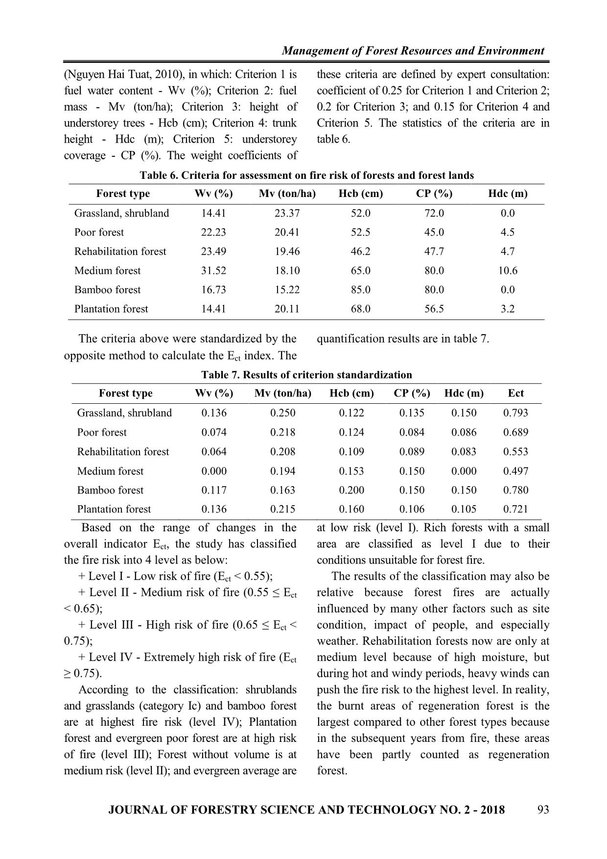
(Nguyen Hai Tuat, 2010), in which: Criterion 1 is these criteria are defined by expert consultation:
fuel water content - Wv (%); Criterion 2: fuel coefficient of 0.25 for Criterion 1 and Criterion 2;
mass - Mv (ton/ha); Criterion 3: height of 0.2 for Criterion 3; and 0.15 for Criterion 4 and
understorey trees - Hcb (cm); Criterion 4: trunk Criterion 5. The statistics of the criteria are in
height - Hdc (m); Criterion 5: understorey table 6.
coverage - CP (%). The weight coefficients of
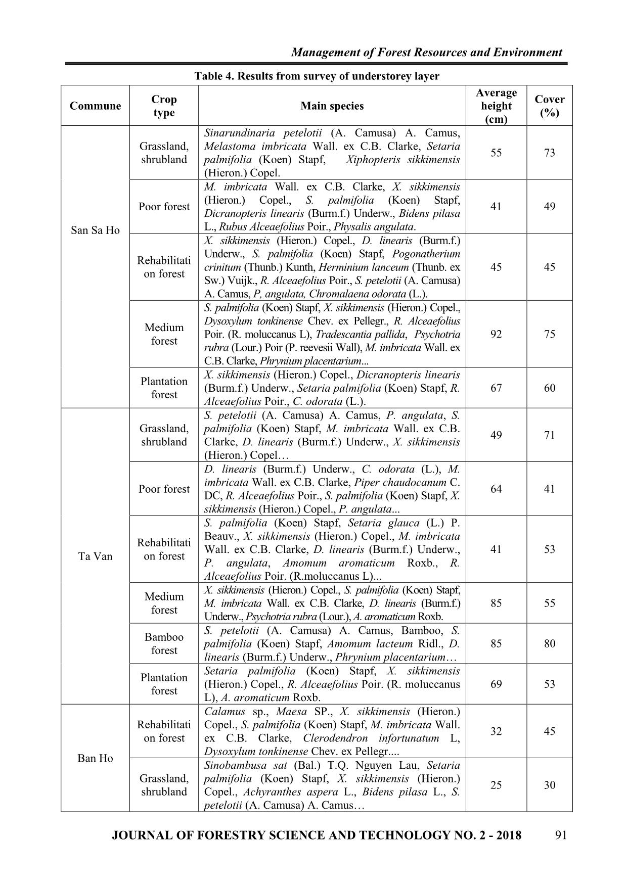
 Table 6. Criteria for assessment on fire risk of forests and forest lands
 Forest type Wv (%) Mv (ton/ha) Hcb (cm) CP (%) Hdc (m)
 Grassland, shrubland 14.41 23.37 52.0 72.0 0.0
 Poor forest 22.23 20.41 52.5 45.0 4.5
 Rehabilitation forest 23.49 19.46 46.2 47.7 4.7
 Medium forest 31.52 18.10 65.0 80.0 10.6
 Bamboo forest 16.73 15.22 85.0 80.0 0.0
 Plantation forest 14.41 20.11 68.0 56.5 3.2
 The criteria above were standardized by the quantification results are in table 7.
opposite method to calculate the Ect index. The
 Table 7. Results of criterion standardization
 Forest type Wv (%) Mv (ton/ha) Hcb (cm) CP (%) Hdc (m) Ect
 Grassland, shrubland 0.136 0.250 0.122 0.135 0.150 0.793
 Poor forest 0.074 0.218 0.124 0.084 0.086 0.689
 Rehabilitation forest 0.064 0.208 0.109 0.089 0.083 0.553
 Medium forest 0.000 0.194 0.153 0.150 0.000 0.497
 Bamboo forest 0.117 0.163 0.200 0.150 0.150 0.780
 Plantation forest 0.136 0.215 0.160 0.106 0.105 0.721
 Based on the range of changes in the at low risk (level I). Rich forests with a small
overall indicator Ect, the study has classified area are classified as level I due to their
the fire risk into 4 level as below: conditions unsuitable for forest fire.
 + Level I - Low risk of fire (Ect < 0.55); The results of the classification may also be
 + Level II - Medium risk of fire (0.55 ≤ Ect relative because forest fires are actually
< 0.65); influenced by many other factors such as site
 + Level III - High risk of fire (0.65 ≤ Ect < condition, impact of people, and especially
0.75); weather. Rehabilitation forests now are only at
 + Level IV - Extremely high risk of fire (Ect medium level because of high moisture, but
≥ 0.75). during hot and windy periods, heavy winds can
 According to the classification: shrublands push the fire risk to the highest level. In reality,
and grasslands (category Ic) and bamboo forest the burnt areas of regeneration forest is the
are at highest fire risk (level IV); Plantation largest compared to other forest types because
forest and evergreen poor forest are at high risk in the subsequent years from fire, these areas
of fire (level III); Forest without volume is at have been partly counted as regeneration
medium risk (level II); and evergreen average are forest.
 JOURNAL OF FORESTRY SCIENCE AND TECHNOLOGY NO. 2 - 2018 93
 Management of Forest Resources and Environment
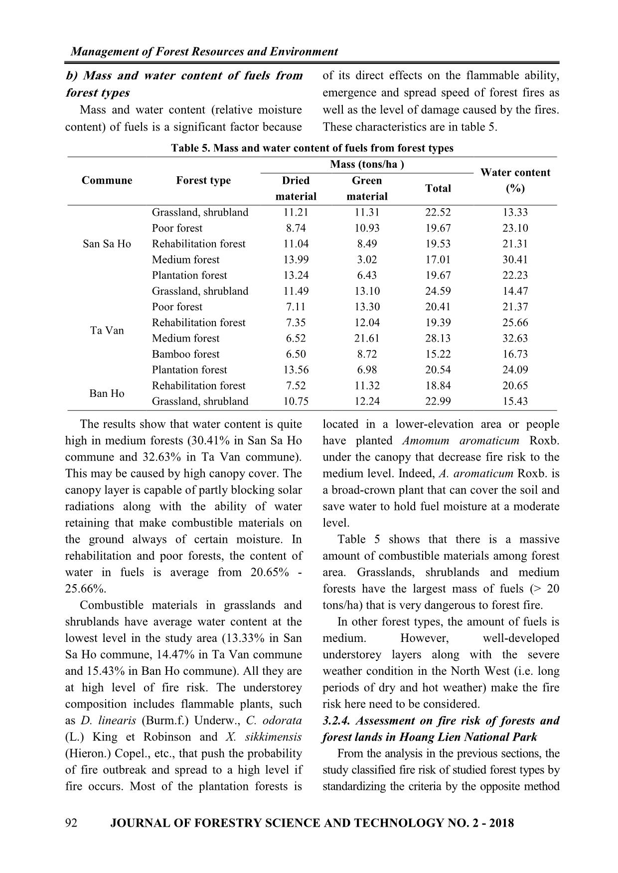
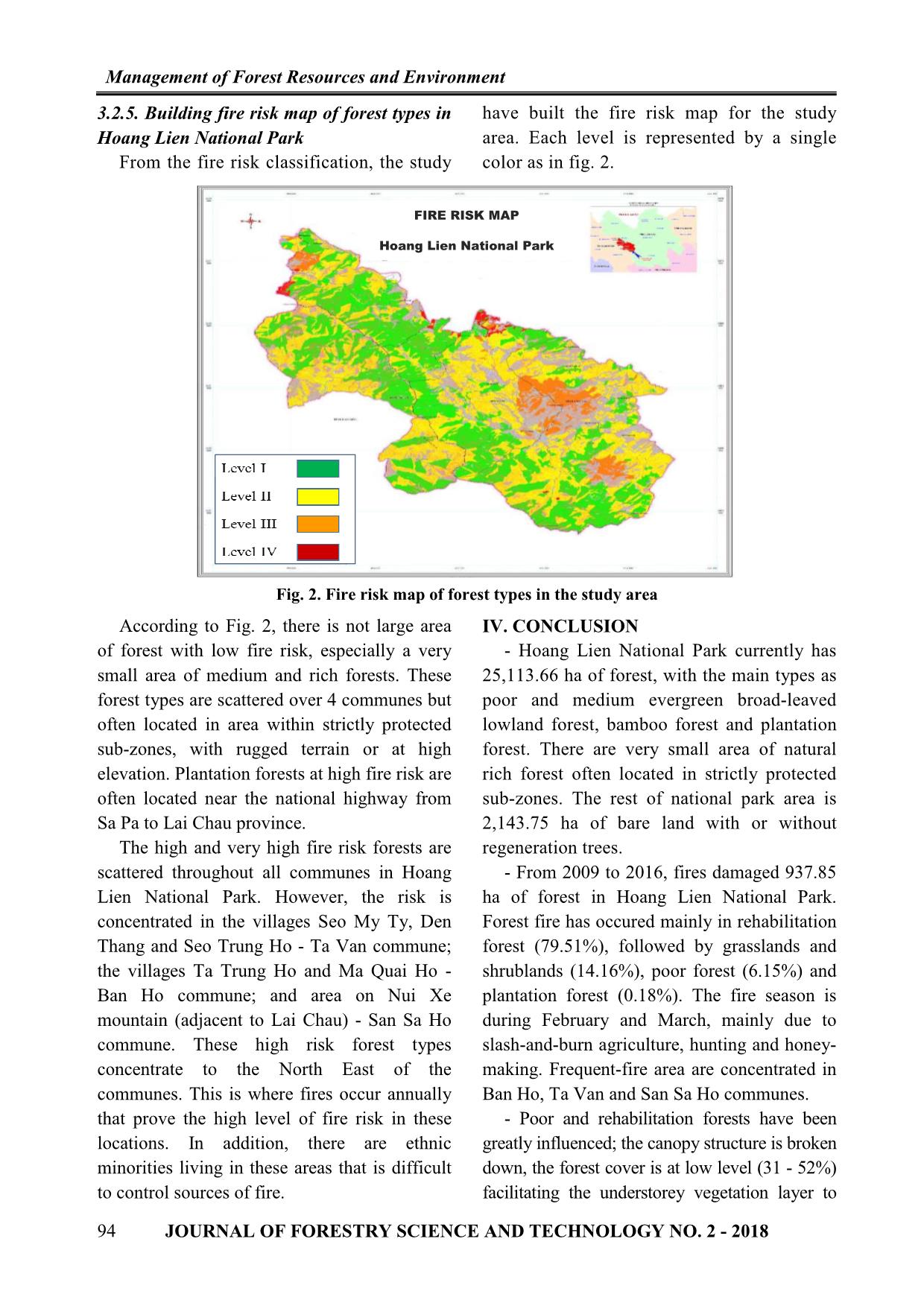
3.2.5. Building fire risk map of forest types in have built the fire risk map for the study
Hoang Lien National Park area. Each level is represented by a single
 From the fire risk classification, the study color as in fig. 2.
 FIRE RISK MAP
 Hoang Lien National Park
 Fig. 2. Fire risk map of forest types in the study area
 According to Fig. 2, there is not large area IV. CONCLUSION
of forest with low fire risk, especially a very - Hoang Lien National Park currently has
small area of medium and rich forests. These 25,113.66 ha of forest, with the main types as
forest types are scattered over 4 communes but poor and medium evergreen broad-leaved
often located in area within strictly protected lowland forest, bamboo forest and plantation
sub-zones, with rugged terrain or at high forest. There are very small area of natural
elevation. Plantation forests at high fire risk are rich forest often located in strictly protected
often located near the national highway from sub-zones. The rest of national park area is
Sa Pa to Lai Chau province. 2,143.75 ha of bare land with or without
 The high and very high fire risk forests are regeneration trees.
scattered throughout all communes in Hoang - From 2009 to 2016, fires damaged 937.85
Lien National Park. However, the risk is ha of forest in Hoang Lien National Park.
concentrated in the villages Seo My Ty, Den Forest fire has occured mainly in rehabilitation
Thang and Seo Trung Ho - Ta Van commune; forest (79.51%), followed by grasslands and
the villages Ta Trung Ho and Ma Quai Ho - shrublands (14.16%), poor forest (6.15%) and
Ban Ho commune; and area on Nui Xe plantation forest (0.18%). The fire season is
mountain (adjacent to Lai Chau) - San Sa Ho during February and March, mainly due to
commune. These high risk forest types slash-and-burn agriculture, hunting and honey-
concentrate to the North East of the making. Frequent-fire area are concentrated in
communes. This is where fires occur annually Ban Ho, Ta Van and San Sa Ho communes.
that prove the high level of fire risk in these - Poor and rehabilitation forests have been
locations. In addition, there are ethnic greatly influenced; the canopy structure is broken
minorities living in these areas that is difficult down, the forest cover is at low level (31 - 52%)
to control sources of fire. facilitating the understorey vegetation layer to
94 JOURNAL OF FORESTRY SCIENCE AND TECHNOLOGY NO. 2 - 2018
 Management of Forest Resources and Environment
well develop. In each forest type, there are forest fire characteristics and other socio-
different vegetation characteristics, thus forming economic factors, to propose solution for forest
different fuel sources for fire. fire prevention and suppression following
 - There is a clear difference in fuel scientific and practical bases.
characteristics among forest types, including REFERENCES
trunk height, height and coverage of 1. Heikkila T. V., Gronqvist R., Jurvelius R. M.
understorey trees, mass and moisture of (2010). Wildland Fire Management. Forest Management
combustible materials. Team, Forestry Department, FAO. Rome.
 2. Hoang Lien National Park (2014). Adjustment and
 - Based on characteristics of combustible
 supplement to the plan for forest fire prevention and
materials, the study successfully classified forest suppression in the dry season 2014-2015.
types by fire risk into 4 levels as follows: 3. Hoang Lien National Park (2016). Statistics of
shrublands and grasslands (category Ic) and forest area in Hoang Lien National Park.
bamboo forest are at highest fire risk (level IV); 4. Hoang Lien National Park (2017). Report on fire
Plantation forest and evergreen poor forest are at situation in Hoang Lien National Park.
high risk of fire (level III); Forest without 5. Nguyen Hai Tuat, Tran Quang Bao, Vu Tien
 Thinh (2010). Quantitative ecological research methods.
volume is at medium risk (level II) and evergreen
 Agriculture publisher, Ha Noi.
average are at low risk (level I). 6. Vietnam Government (2006). The decree No.
 From those results, it is necessary to further 09/2006/ND-CP on fire prevention and supppression.
study on other factors, such as terrain, climate, Ha Noi.
ĐẶC ĐIỂM VẬT LIỆU VÀ NGUY CƠ CHÁY Ở CÁC TRẠNG THÁI RỪNG
 CHỦ YẾU TẠI VƯỜN QUỐC GIA HOÀNG LIÊN
 Trần Minh Cảnh1, Lê Thái Sơn2, Lê Xuân Thắng3
 1Trường Đại học Hải Dương
 2Trường Đại học Lâm nghiệp
 3Vườn Quốc gia Hoàng Liên
 TÓM TẮT
 Vườn quốc gia Hoàng Liên hiện quản lý 25.113,66 ha rừng, với các trạng thái chủ yếu: rừng gỗ tự nhiên lá
 rộng thường xanh nghèo, trung bình, rừng phục hồi, rừng tre nứa và rừng trồng. Rừng tự nhiên giàu hiện còn
 rất ít, thường phân bố ở phân khu bảo vệ nghiêm ngặt và 2.143,75 ha đất trống không hoặc có cây gỗ tái sinh.
 Có sự khác nhau khá rõ về đặc điểm vật liệu cháy (VLC) ở các trạng thái rừng, qua những chỉ tiêu gồm: Chiều
 cao dưới cành tầng cây cao, chiều cao và độ che phủ của lớp thảm tươi cây bụi, khối lượng và độ ẩm VLC. Từ
 đặc điểm VLC, phân nguy cơ cháy của các trạng thái rừng và trảng cỏ, cây bụi thành 4 cấp theo mức độ nguy
 hiểm với lửa như sau: trạng thái trảng cỏ cây bụi và rừng tre nứa có nguy cơ cháy cao nhất (cấp IV); trạng thái
 rừng trồng và rừng thường xanh nghèo có nguy cơ cháy ở mức cao (cấp III); rừng phục hồi có nguy cơ cháy ở
 mức trung bình (cấp II); rừng thường xanh trung bình và giàu có nguy cơ cháy thấp (cấp I). Từ kết quả phân
 cấp nguy cơ cháy rừng như trên, xây dựng bản đồ phân cấp nguy cơ cháy cho các trạng thái rừng ở Vườn Quốc
 gia Hoàng Liên.
 Từ khóa: Đặc điểm vật liệu cháy, nguy cơ cháy rừng, phòng cháy - chữa cháy rừng, trạng thái rừng,
 Vườn Quốc gia Hoàng Liên.
 Received : 07/02/2018
 Revised : 06/3/2018
 Accepted : 14/3/2018
 JOURNAL OF FORESTRY SCIENCE AND TECHNOLOGY NO. 2 - 2018 95
File đính kèm:
 characteristics_of_fuels_and_fire_risk_among_the_main_forest.pdf

