Some improvements of fuzzy clustering algorithms using picture fuzzy sets and applications for geographic data clustering
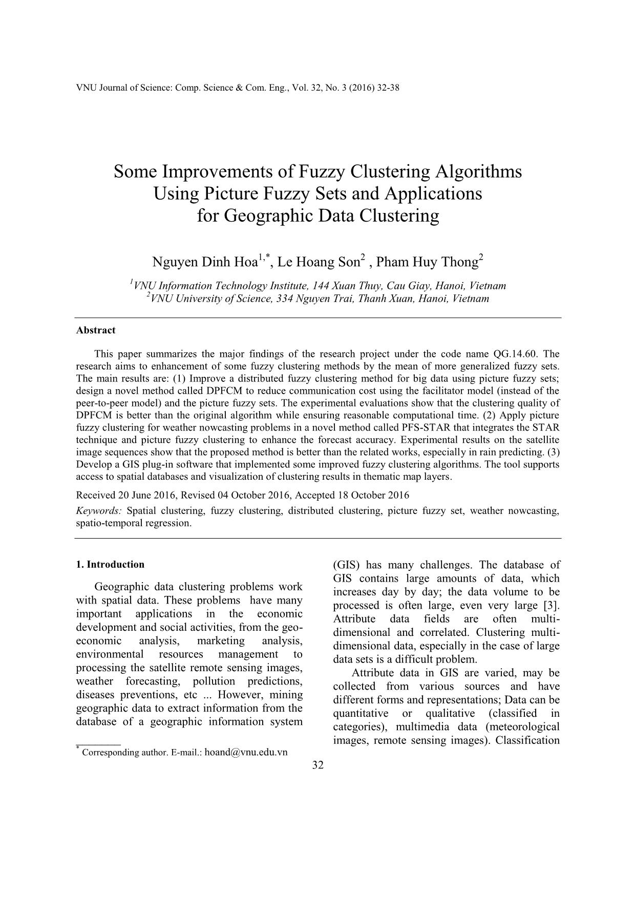
This paper summarizes the major findings of the research project under the code name QG.14.60. The
research aims to enhancement of some fuzzy clustering methods by the mean of more generalized fuzzy sets.
The main results are: (1) Improve a distributed fuzzy clustering method for big data using picture fuzzy sets;
design a novel method called DPFCM to reduce communication cost using the facilitator model (instead of the
peer-to-peer model) and the picture fuzzy sets. The experimental evaluations show that the clustering quality of
DPFCM is better than the original algorithm while ensuring reasonable computational time. (2) Apply picture
fuzzy clustering for weather nowcasting problems in a novel method called PFS-STAR that integrates the STAR
technique and picture fuzzy clustering to enhance the forecast accuracy. Experimental results on the satellite
image sequences show that the proposed method is better than the related works, especially in rain predicting. (3)
Develop a GIS plug-in software that implemented some improved fuzzy clustering algorithms. The tool supports
access to spatial databases and visualization of clustering results in thematic map layers.
Trang 1
Trang 2
Trang 3
Trang 4
Trang 5
Trang 6
Trang 7
Tóm tắt nội dung tài liệu: Some improvements of fuzzy clustering algorithms using picture fuzzy sets and applications for geographic data clustering
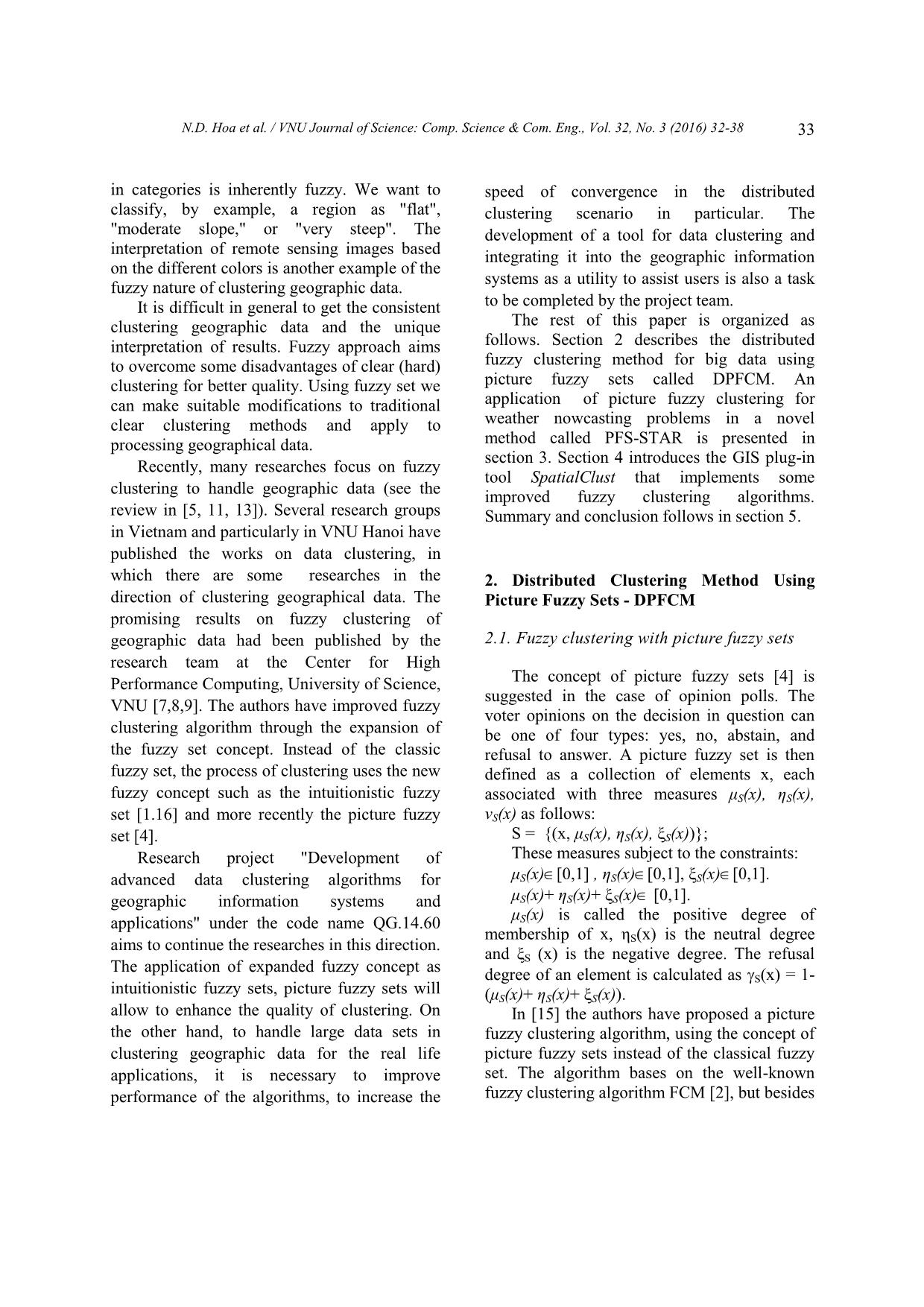
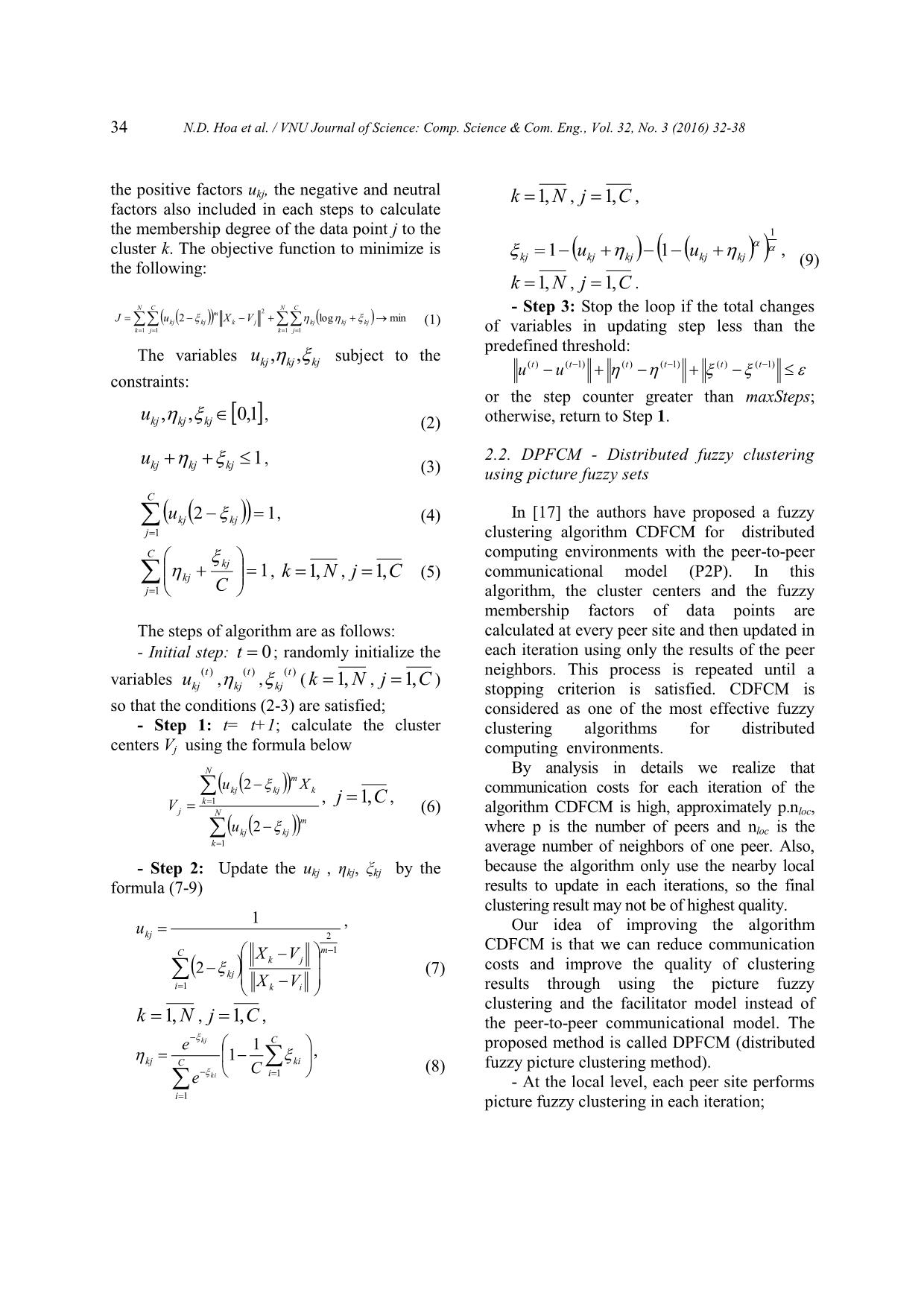
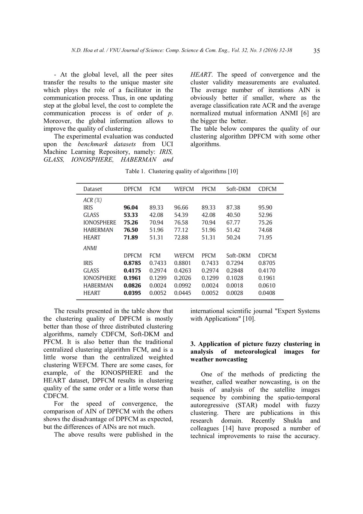
to the kj kj kj u (t) u (t 1) (t) (t 1) (t) (t 1) constraints: or the step counter greater than maxSteps; , ukj ,kj ,kj 0,1 (2) otherwise, return to Step 1. 2.2. DPFCM - Distributed fuzzy clustering ukj kj kj 1, (3) using picture fuzzy sets C In [17] the authors have proposed a fuzzy ukj 2 kj 1, (4) j 1 clustering algorithm CDFCM for distributed C computing environments with the peer-to-peer kj kj 1, k 1, N , j 1,C (5) communicational model (P2P). In this j 1 C algorithm, the cluster centers and the fuzzy membership factors of data points are The steps of algorithm are as follows: calculated at every peer site and then updated in - Initial step: t 0; randomly initialize the each iteration using only the results of the peer (t) (t) (t) neighbors. This process is repeated until a variables u , , ( k 1, N , j 1,C ) kj kj kj stopping criterion is satisfied. CDFCM is so that the conditions (2-3) are satisfied; considered as one of the most effective fuzzy - Step 1: t= t+1; calculate the cluster clustering algorithms for distributed centers Vj using the formula below computing_environments. N By analysis in details we realize that m ukj 2 kj X k communication costs for each iteration of the k 1 , j 1,C , V j N (6) algorithm CDFCM is high, approximately p.nloc, m ukj 2 kj where p is the number of peers and nloc is the k 1 average number of neighbors of one peer. Also, - Step 2: Update the ukj , ηkj, ξkj by the because the algorithm only use the nearby local formula (7-9) results to update in each iterations, so the final clustering result may not be of highest quality. 1 , Our idea of improving the algorithm ukj 2 CDFCM is that we can reduce communication C X V m 1 2 k j (7) costs and improve the quality of clustering kj X V i 1 k i results through using the picture fuzzy clustering and the facilitator model instead of k 1, N , j 1,C , the peer-to-peer communicational model. The e kj 1 C proposed method is called DPFCM (distributed 1 , kj C ki (8) fuzzy picture clustering method). ki C i 1 e - At the local level, each peer site performs i 1 picture fuzzy clustering in each iteration; N.D. Hoa et al. / VNU Journal of Science: Comp. Science & Com. Eng., Vol. 32, No. 3 (2016) 32-38 35 - At the global level, all the peer sites HEART. The speed of convergence and the transfer the results to the unique master site cluster validity measurements are evaluated. which plays the role of a facilitator in the The average number of iterations AIN is communication process. Thus, in one updating obviously better if smaller, where as the step at the global level, the cost to complete the average classification rate ACR and the average communication process is of order of p. normalized mutual information ANMI [6] are Moreover, the global information allows to the bigger the_better. improve the quality of clustering. The table below compares the quality of our The experimental evaluation was conducted clustering algorithm DPFCM with some other upon the benchmark datasets from UCI algorithms. k Machine Learning Repository, namely: IRIS, h GLASS, IONOSPHERE, HABERMAN and F Table 1. Clustering quality of algorithms [10] k The results presented in the table show that international scientific journal "Expert Systems the clustering quality of DPFCM is mostly with Applications" [10]. better than those of three distributed clustering algorithms, namely CDFCM, Soft-DKM and PFCM. It is also better than the traditional 3. Application of picture fuzzy clustering in centralized clustering algorithm FCM, and is a analysis of meteorological images for little worse than the centralized weighted weather nowcasting clustering WEFCM. There are some cases, for example, of the IONOSPHERE and the One of the methods of predicting the HEART dataset, DPFCM results in clustering weather, called weather nowcasting, is on the quality of the same order or a little worse than basis of analysis of the satellite images CDFCM. sequence by combining the spatio-temporal For the speed of convergence, the autoregressive (STAR) model with fuzzy comparison of AIN of DPFCM with the others clustering. There are publications in this shows the disadvantage of DPFCM as expected, research domain. Recently Shukla and but the differences of AINs are not much. colleagues [14] have proposed a number of The above results were published in the technical improvements to raise the accuracy. 36 N.D. Hoa et al. / VNU Journal of Science: Comp. Science & Com. Eng., Vol. 32, No. 3 (2016) 32-38 However, because using classical fuzzy sets, the Table 2. Comparison of RMSE and computational image areas of ambiguous interpretation or lack time of PFC-STAR and the method of clarity have the negative impacts to the of Shukla et al [12] prediction result. Picture fuzzy clustering [15] Computational RMSE (%) using more advanced fuzzy concept has been time (sec) shown that is better than the traditional fuzzy Shukla Shukla Data clustering. Our idea is advancing the research of PFC- et al. PFC- et al. Shukla et al, through combining the primary STAR (2014)’s STAR (2014)’s STAR techniques with picture fuzzy clustering method method to create a new weather prediction method, Malaysia 26.77 27.11 362.745 359.88 Luzon – called Picture Fuzzy Clustering - 33.61 33.45 345.672 343.43 Spatiotemporal autoregressive (PFC-STAR). Philippines Jakarta – We hope that the combination can improve the 30.12 32.04 342.76 339.97 quality of the prediction results. The proposed Indonesia PFC-STAR method involves three steps: - The pixels of satellite images (training 4. Developing data clustering tool as a plug- samples) are divided into groups by using in for GIS picture fuzzy clustering algorithm proposed in_[15]. For the convenience of users in mining - All the elements of these clusters in geographical data, a data clustering engine training samples are then labeled and filtered should be developed and integrated into GIS to using the Discrete Fourier Transform to clarify support direct access of spatial database for non-predictable scale to increase the time range reading input data and displaying the results on of predictability. the map layers. - Finally, the next sequence of images are MapWindow is an open source GIS predicted through spatio-temporal auto- software that Windows users are familiar with regression method, which allows the weather and it is currently being developed and the forecast for the chosen geographic area in a latest version released continuously. short time ahead. MapWindow support plug-ins in the form of - The experimental evaluation of the dynamic link libraries (.dll *), and the proposed method was conducted on the development environment such as Visual personal computer of 2 GB RAM, 2.13 GHz Studio Community Edition is available for free core 2 Duo, upon the data sets, which is the download. This tool supports using the sequence of satellite images of the Southeast language C# and dot.NET frame. Our Asia region. Each data set includes 5 satellite implementation of the proposed algorithms to images taken over a time period from 9:30 to run experimental evaluation is conducted using 13:30, of 100 x 100 pixels in size. Comparison C / C ++, therefore the Visual Studio of the results showed that the method proposed development environment in the most suitable here is better than the relevant methods of choice to put our source code into. weather nowcasting, especially with higher The plug-in named SpatialClust is a precision of the rain-rate regression. clustering tool module for geographical data, The above results have been presented and which deployed several fuzzy clustering published in the Proceedings of the algorithms with improvements that our team International Symposium on Geo-informatics has proposed as presented above. Restrictions for Spatial Infrastructure Development in Earth on computational resources of a plug-in does and Allied Sciences (GIS-IDEAS)" [12]. not allow to implement the distributed algorithms or to process large data sets. Hence, N.D. Hoa et al. / VNU Journal of Science: Comp. Science & Com. Eng., Vol. 32, No. 3 (2016) 32-38 37 only some appropriate algorithms are included clustering to process large data sets in order to in the tool, namely: FCM, NE, FGWC, apply for geographical data clustering. The CFGWC, IPFGWC, MIPFGWC. The plug-in results contribute to better address real-world supports direct access of spatial database for problems we meet in many application areas. reading attribute values and displaying the The distributed fuzzy clustering algorithm resulting clusters in different colors on the map. to handle large data sets using picture fuzzy sets Input: data file format is *.csv (coma called DPFCM has improved overall clustering separated values). All the GIS software have to quality in comparison with the algorithm of support importing and exporting data in the Chen and colleagues [17]. Clustering quality of *.shp format of one map layer to the *.csv DPFCM is better than some clustering format. algorithms of the same type, but the computational time does not add much. The new weather nowcasting method PFC-STAR using picture fuzzy sets instead of classical fuzzy sets has allowed raising the quality of predictions in comparison with the method of Shukla et al [14], especially in predicting rain- rate. We can conclude that the use of picture fuzzy clustering actually had a positive impact on the quality of the clustering results for the problems related to the inherently fuzzy concepts. The software tool for data clustering integrated into MapWindow as a plug-in that performs typical fuzzy clustering algorithms Picture 1. Dialog box for choosing input and the improvements proposed in our data and algorithm. researches will help to promote practical Output: there are two types: applications of geographic data mining in 1. Output as text file (*.txt or plain text) to various domains. provide enough detail for the purposes of analysis and evaluation of algorithms or for the Acknowledgements subsequent treatment, if any. 2. Displaying visually on the map: in The authors would like to thank the parallel with printing the results to a text file, colleagues for comments through discussions in the tool allows updated cluster labels directly to the scientific seminars which help to correct the the cluster column of database beneath and by errors and to complete the results achieved. We setting GIS functionalities users can show also express our sincere thanks to VNU Hanoi visualization of clusters on maps. For this for funding the research project under the code purpose, the properties table of map layer must name QG.14.60 and for other supports to have the last column named CLUSTER. conduct the research. 5. Summary and conclusions References The research we carried out in the research [1] Atanassov, K. T. (1986). Intuitionistic fuzzy sets. project has contributed to improve fuzzy Fuzzy Sets and Systems, 20, 87-96. clustering algorithms, distributed fuzzy 38 N.D. Hoa et al. / VNU Journal of Science: Comp. Science & Com. Eng., Vol. 32, No. 3 (2016) 32-38 [2] Bezdek, J.C., R. Ehrlich, et al (1984), FCM: the [11] Neethu C V, Subu Surendran, Review of Spatial fuzzy c-means clustering algorithm, Computers Clustering Methods, International Journal of and Geosciences, 10, pp.191-203 Information Technology Infrastructure, Volume [3] Brinkoff, T., Kriegel, H.-P. (1994), The Impact 2, No.3, May - June_2013. of Global Clustering on Spatial Database [12] Nguyen Dinh Hoa, Pham Huy Thong, Le Hoang Systems, Proceedings of the 2th VLDB Son, “Weather Nowcasting from Satellite Image Conference, Santiago, Chile, pp. 168-179. Sequences Using Picture Fuzzy Clustering and [4] Bui Cong Cuong, Vladik Kreinovich, Picture Spatial-temporal Regression”, International Fuzzy Sets - a new concept for computational Symposium on Geoinformatics for Spatial intelligence problems, Proceeding of 2013 Third Infrastructure Development in Earth_and Allied World Congress on Information and Sciences (GIS-IDEAS), Danang, Vietnam, Communication Technologies (WICT 2013),_1-6. December, 7th-9th , 2014, pp. 137-142 [5] Deepti Joshi, Polygonal Spatial Clustering, [13] M. Perumal, B. Velumani, A. Sadhasivam, and Ph.D. Dissertation, University of K. Ramaswamy, (2015), Spatial Data Mining Nebraska,_2011. Approches for GIS - A Brief Review, Conference [6] Huang, H. C., Chuang, Y. Y., & Chen, C. S. paper, January 2015, © Springer International (2012), Multiple kernel fuzzy clustering, Publishing Switzerland. IEEE_Transactions on Fuzzy Systems, 20(1), [14] Shukla, B. P., Kishtawal, C. M., & Pal, P. K. 120-134. (2014),Prediction of Satellite Image Sequence [7] Le Hoang Son, Bui Cong Cuong, Pier Luca Lanzi, for Weather Nowcasting Using Cluster-Based Hoang Anh Hung (2011) Data Mining in GIS: A Spatiotemporal Regression, IEEE Transactions Novel Context-Based Fuzzy Geographically on Geoscience and Remote Sensing, 52(7), Weighted Clustering Algorithm. International 4155 - 4160. Journal of Machine Learning and Computing. [15] Thong, P.H., Son, L.H. (2014). A new approach [8] Le Hoang Son (2011), Nguyen Dinh Hoa, Pier to multi-variables fuzzy forecasting using picture Luca Lanzi, and Bui Thi Huong Lan, A fuzzy clustering and picture fuzzy rules Combination of Clustering Techniques and interpolation method, Proceeding of 6th Fuzzy Control in 2D Polygon Determination for International Conference on Knowledge and the Terrain Splitting and Mapping Problem, Systems Engineering (KSE 2014), October 9-11, International Journal of Computer and Electrical 2014, Hanoi, Vietnam, 679 - 690. Engineering 3(5), pp. 682 – 689. [16] Visalakshi, N. K., Thangavel, K., & Parvathi, R. [9] Le Hoang Son, Bui Cong Cuong, Pier Luca (2010). An intuitionistic fuzzy approach to Lanzi, Nguyen Tho Thong (2012), A Novel distributed fuzzy clustering, International Journal Intuitionistic Fuzzy Clustering Method for Geo- of Computer Theory and Engineering, 2 (2), Demographic Analysis, Expert Systems with 1793–8201. Applications. [17] Zhou, J., Chen, C., Chen, L., & Li, H. (2013). A [10] Le Hoang Son (2015), “DPFCM: A novel collaborative fuzzy clustering algorithm in distributed picture fuzzy clustering method on distributed network environments, IEEE picture fuzzy sets”, Expert Systems with Transactions on Fuzzy Systems. Applications, 42 (2015) pp. 51-66.
File đính kèm:
 some_improvements_of_fuzzy_clustering_algorithms_using_pictu.pdf

