Assessment of Land Resources Potentials for Orientation of Agriculture Land Use in Ham Thuan Bac district, Binh Thuan province
Land resources potential assessment is a valuable method for
orienting land use planning in the world as well as in Vietnam. This
study aimed to (1) assess land suitability and (2) orient the effective
use of agricultural land in the study area. Results indicated that Ham
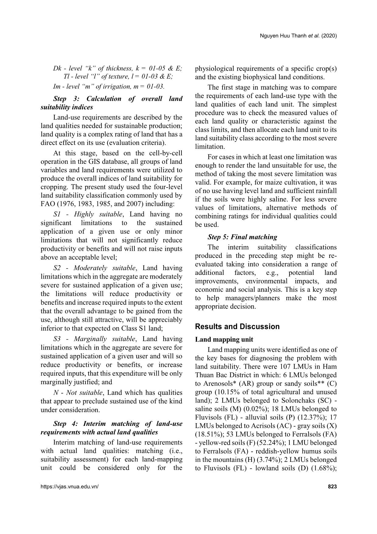
Thuan Bac had 107 land mapping units (LMUs) with 11 main landuse types (LUTs) such as rice, cassava, vegetables, dragon fruit, and
other trees. Agricultural land with high (S1) and moderate suitability
(S2) for most LUTs was small; however, marginal (S3) and not
suitability (N) lands were quite large. Results of land suitability
evaluation on current land use showed that land area of annual crops
was mainly found at the S3 suitability level, specifically for the rice
area, 67.75% was marginally suitable and 23.29% of the area was
unsuitable; In terms of perennial trees, except for dragon fruits which
were mainly cultivated at the S2 suitability level (78.28%), the others
such as cashew and other fruit trees were S3 and N levels. Based on
land suitability classification, for mainstay LUTs, we proposed to
keep 8550.0ha with S1, S2, and a part of S3 area to be irrigated for
cultivating rice; 9071.7ha of dragon fruit land including 694.67ha of
S1 and 8377.03ha of S2 land; only cultivate annual crops, fruit trees
and grazing grass on the land with suitable levels from S1 to S3 of
the current status; and the remaining areas of S3 and N levels for rice
and areas of S2, S3, or N levels for dragon fruit would be converted
to lands for annual crops, fruit trees, or grass for livestock.
Trang 1
Trang 2
Trang 3
Trang 4
Trang 5
Trang 6
Trang 7
Trang 8
Trang 9
Trang 10
Tải về để xem bản đầy đủ
Tóm tắt nội dung tài liệu: Assessment of Land Resources Potentials for Orientation of Agriculture Land Use in Ham Thuan Bac district, Binh Thuan province
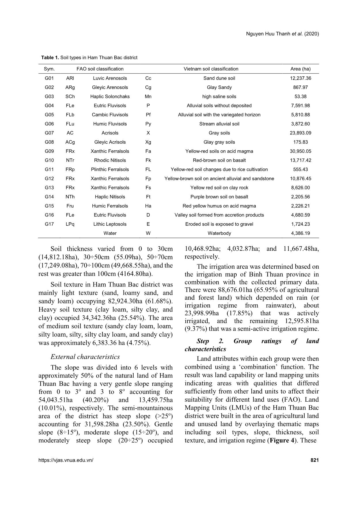
1
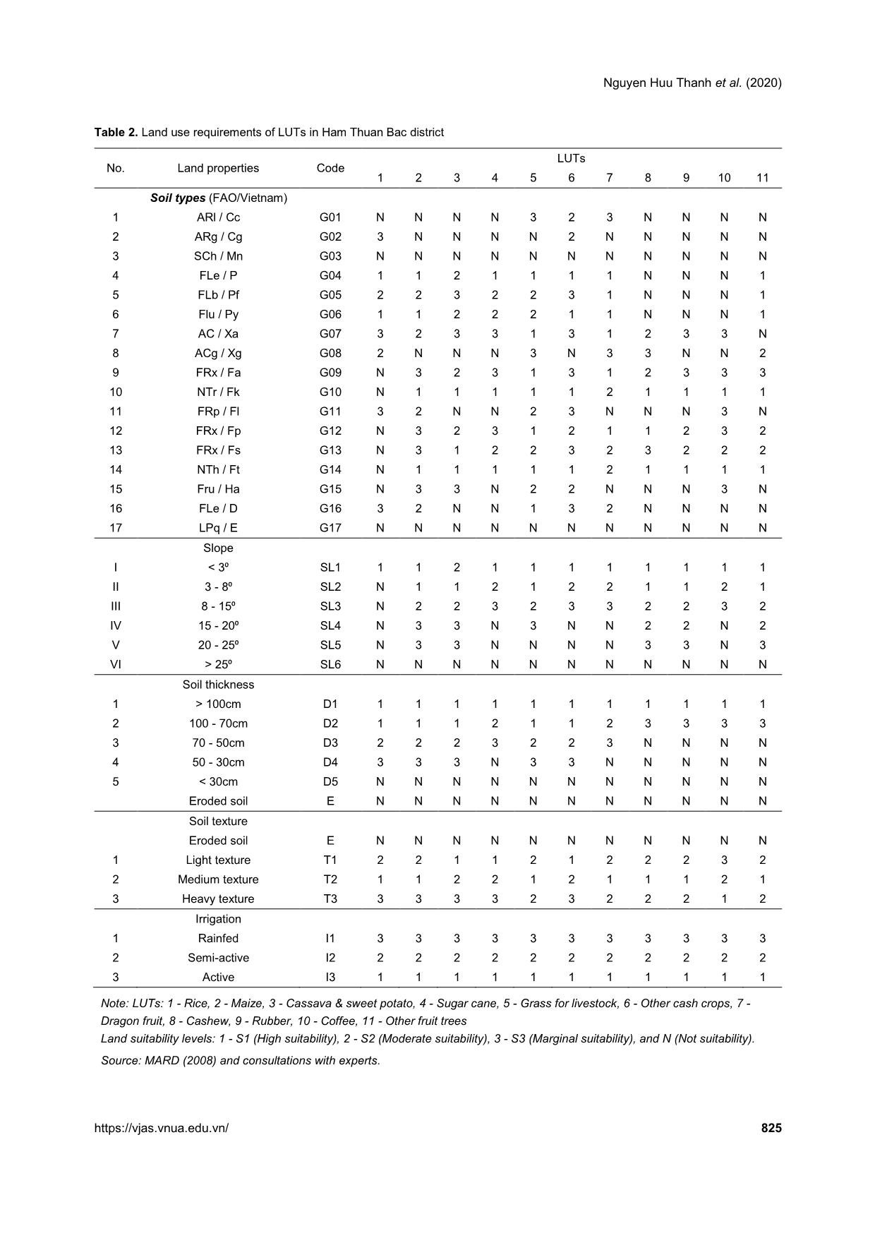
 Soil types (FAO/Vietnam)
1 ARl / Cc G01 N N N N 3 2 3 N N N N
2 ARg / Cg G02 3 N N N N 2 N N N N N
3 SCh / Mn G03 N N N N N N N N N N N
4 FLe / P G04 1 1 2 1 1 1 1 N N N 1
5 FLb / Pf G05 2 2 3 2 2 3 1 N N N 1
6 Flu / Py G06 1 1 2 2 2 1 1 N N N 1
7 AC / Xa G07 3 2 3 3 1 3 1 2 3 3 N
8 ACg / Xg G08 2 N N N 3 N 3 3 N N 2
9 FRx / Fa G09 N 3 2 3 1 3 1 2 3 3 3
10 NTr / Fk G10 N 1 1 1 1 1 2 1 1 1 1
11 FRp / Fl G11 3 2 N N 2 3 N N N 3 N
12 FRx / Fp G12 N 3 2 3 1 2 1 1 2 3 2
13 FRx / Fs G13 N 3 1 2 2 3 2 3 2 2 2
14 NTh / Ft G14 N 1 1 1 1 1 2 1 1 1 1
15 Fru / Ha G15 N 3 3 N 2 2 N N N 3 N
16 FLe / D G16 3 2 N N 1 3 2 N N N N
17 LPq / E G17 N N N N N N N N N N N
 Slope
I < 3⁰ SL1 1 1 2 1 1 1 1 1 1 1 1
II 3 - 8⁰ SL2 N 1 1 2 1 2 2 1 1 2 1
III 8 - 15⁰ SL3 N 2 2 3 2 3 3 2 2 3 2
IV 15 - 20⁰ SL4 N 3 3 N 3 N N 2 2 N 2
V 20 - 25⁰ SL5 N 3 3 N N N N 3 3 N 3
VI > 25⁰ SL6 N N N N N N N N N N N
 Soil thickness
1 > 100cm D1 1 1 1 1 1 1 1 1 1 1 1
2 100 - 70cm D2 1 1 1 2 1 1 2 3 3 3 3
3 70 - 50cm D3 2 2 2 3 2 2 3 N N N N
4 50 - 30cm D4 3 3 3 N 3 3 N N N N N
5 < 30cm D5 N N N N N N N N N N N
 Eroded soil E N N N N N N N N N N N
 Soil texture
 Eroded soil E N N N N N N N N N N N
1 Light texture T1 2 2 1 1 2 1 2 2 2 3 2
2 Medium texture T2 1 1 2 2 1 2 1 1 1 2 1
3 Heavy texture T3 3 3 3 3 2 3 2 2 2 1 2
 Irrigation
1 Rainfed I1 3 3 3 3 3 3 3 3 3 3 3
2 Semi-active I2 2 2 2 2 2 2 2 2 2 2 2
3 Active I3 1 1 1 1 1 1 1 1 1 1 1
Note: LUTs: 1 - Rice, 2 - Maize, 3 - Cassava & sweet potato, 4 - Sugar cane, 5 - Grass for livestock, 6 - Other cash crops, 7 -
Dragon fruit, 8 - Cashew, 9 - Rubber, 10 - Coffee, 11 - Other fruit trees
Land suitability levels: 1 - S1 (High suitability), 2 - S2 (Moderate suitability), 3 - S3 (Marginal suitability), and N (Not suitability).
Source: MARD (2008) and consultations with experts.
Assessment of land resources potentials for orientation of agriculture land use in Ham Thuan Bac district, Binh Thuan
826 Vietnam Journal of Agricultural Sciences
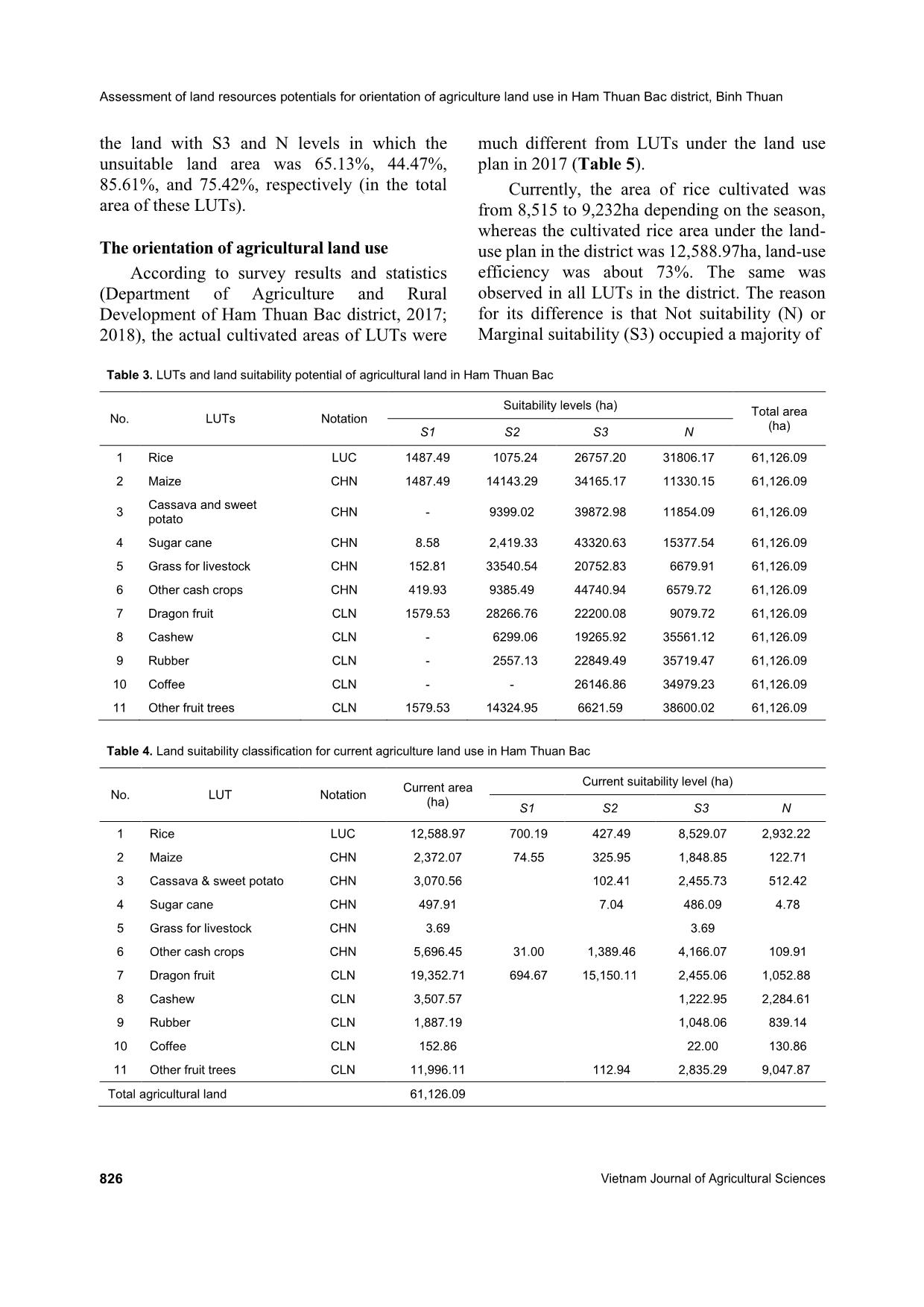
the land with S3 and N levels in which the
unsuitable land area was 65.13%, 44.47%,
85.61%, and 75.42%, respectively (in the total
area of these LUTs).
The orientation of agricultural land use
According to survey results and statistics
(Department of Agriculture and Rural
Development of Ham Thuan Bac district, 2017;
2018), the actual cultivated areas of LUTs were
much different from LUTs under the land use
plan in 2017 (Table 5).
Currently, the area of rice cultivated was
from 8,515 to 9,232ha depending on the season,
whereas the cultivated rice area under the land-
use plan in the district was 12,588.97ha, land-use
efficiency was about 73%. The same was
observed in all LUTs in the district. The reason
for its difference is that Not suitability (N) or
Marginal suitability (S3) occupied a majority of
 Table 3. LUTs and land suitability potential of agricultural land in Ham Thuan Bac
No. LUTs Notation
Suitability levels (ha)
Total area
(ha)
S1 S2 S3 N
1 Rice LUC 1487.49 1075.24 26757.20 31806.17 61,126.09
2 Maize CHN 1487.49 14143.29 34165.17 11330.15 61,126.09
3
Cassava and sweet
potato
CHN - 9399.02 39872.98 11854.09 61,126.09
4 Sugar cane CHN 8.58 2,419.33 43320.63 15377.54 61,126.09
5 Grass for livestock CHN 152.81 33540.54 20752.83 6679.91 61,126.09
6 Other cash crops CHN 419.93 9385.49 44740.94 6579.72 61,126.09
7 Dragon fruit CLN 1579.53 28266.76 22200.08 9079.72 61,126.09
8 Cashew CLN - 6299.06 19265.92 35561.12 61,126.09
9 Rubber CLN - 2557.13 22849.49 35719.47 61,126.09
10 Coffee CLN - - 26146.86 34979.23 61,126.09
11 Other fruit trees CLN 1579.53 14324.95 6621.59 38600.02 61,126.09
 Table 4. Land suitability classification for current agriculture land use in Ham Thuan Bac
No. LUT Notation
Current area
(ha)
Current suitability level (ha)
S1 S2 S3 N
1 Rice LUC 12,588.97 700.19 427.49 8,529.07 2,932.22
2 Maize CHN 2,372.07 74.55 325.95 1,848.85 122.71
3 Cassava & sweet potato CHN 3,070.56 102.41 2,455.73 512.42
4 Sugar cane CHN 497.91 7.04 486.09 4.78
5 Grass for livestock CHN 3.69 3.69
6 Other cash crops CHN 5,696.45 31.00 1,389.46 4,166.07 109.91
7 Dragon fruit CLN 19,352.71 694.67 15,150.11 2,455.06 1,052.88
8 Cashew CLN 3,507.57 1,222.95 2,284.61
9 Rubber CLN 1,887.19 1,048.06 839.14
10 Coffee CLN 152.86 22.00 130.86
11 Other fruit trees CLN 11,996.11 112.94 2,835.29 9,047.87
Total agricultural land 61,126.09
Nguyen Huu Thanh et al. (2020)
https://vjas.vnua.edu.vn/ 827
(a) (b)
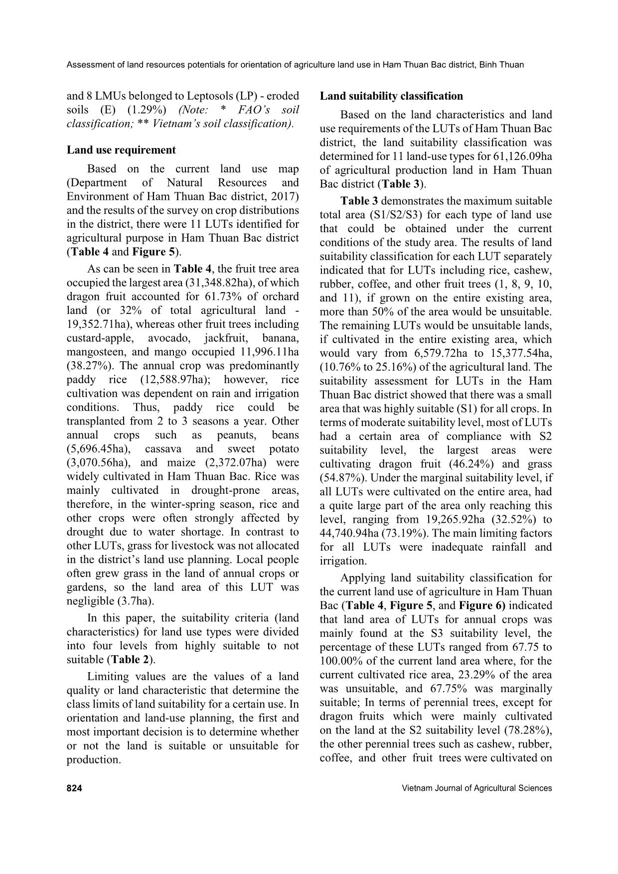
Figure 4. The current status map of agricultural land use in 2017 (a) and Map of land suitability classification for current agricultural
land-use (b) of Ham Thuan Bac district
Figure 5. Land adaptation map (or land potential)
Assessment of land resources potentials for orientation of agriculture land use in Ham Thuan Bac district, Binh Thuan
828 Vietnam Journal of Agricultural Sciences
 Table 5. The actual cultivated area in 2017 and 2018 in Ham Thuan Bac district
No. LUT Area (ha)
Actual cultivated area (ha)
Winter-spring Summer-autumn Autumn
16-17 17-18 2017 2018 2017 2018
1 Rice 12,588.97 8,515.0 8,545.0 9,171.0 9,000.0 9,323.0 9,079.0
2 Maize 2,372.07 75.5 68.0 528.0 619.0 1,327.0 1,526.0
3
Cassava and sweet
potato
3,070.56 9.5 10.0 1,086.0 1,148.0 44.0 10.0
4 Sugar cane 497.91 269.0 164.0 1,552.0 1,403.0 39.0 41.0
5 Grass for livestock 3.69 3.7 3.7 3.7 3.7 3.7 3.7
6 Other cash crops 5,696.45 1,031.0 797.5 1247 1,410.0 1,134.0 1,438.0
7 Dragon fruit 19,352.71 9,000.0 9,071.7
8 Cashew 3,507.57 1,365.0 1,728.0
9 Rubber 1,887.19 1,531.0 1,531.0
10 Coffee 152.86 1,550.0 1,634.0
11 Other fruit trees 11,996.11 858.0 1,300.0
the land area (Table 4). The district was not able
to effectively use the land resources potentials if
the limiting factors such as irrigation and shifting
crop structure to adapt to water shortage
conditions were not improved. Besides, the
general limitation of the region was drought in
the dry season (November to April),
corresponding to winter-spring and early
summer-autumn seasons.
Hence, to meet the requirements of
sustainable land use to land use sustainable we
proposed to: (i) Maintain the land areas which
have High suitability (S1) and Moderate
suitability (S2) levels; (ii) Renovate or convert to
other suitable plants/afforestation for Marginal
suitable (S3) land areas; and (iii) Convert to
afforestation or use plants that could improve soil
quality of the Not Suitable (N) land areas.
Thus, based on the actual land use in Ham
Thuan Bac district, we proposed to keep stable
rice cultivation in the area of 8550ha (including
1,127.68ha of rice under S1 and S2 suitability
levels and 7,422.32ha rice under S3 suitability
level) due to light soil texture (S3) but with active
irrigation regime. The remaining area should be
converted to other annual crops including rice
area with remaining S3 and N suitability levels
(due to yellowish-red soil). More importantly,
due to the consumption market, the actual
cultivated area of dragon fruit was only 9,000ha,
which was much lower than the approved land
use plan (19,352.71ha) of the district. Therefore,
for this LUT, we recommend cultivating dragon
fruit under the S1 suitability level (694.67ha) and
approximately 8,377.03ha under the S2
suitability level. The proposal of dragon fruit
(6,773.08 ha) under the district’s plan should be
shifted to annual crops, other fruit trees (mango
and grapefruit, etc.), and grass for livestock. In
terms of the perennial crop, the majority were
cultivated under Suitability level (S3) and Not
suitability level (N); therefore, we propose
keeping these crops growing under S3, and the
remaining area (12,302.49ha) under N level
should be converted to afforestation and soil
improvement plants.
Conclusions
The analytical procedures developed in the
five specific steps for assessing land suitability
were used to develop an effective use of
agricultural land in Ham Thuan Bac district,
which had an area of 61126.09ha agricultural
land and unused land with 11 common land-use
types, with rice (21% of total agricultural land)
and dragon fruit (32%) as the two main crops.
Two important groups of land attributes for land
suitability analysis including inherent qualities of
Nguyen Huu Thanh et al. (2020)
https://vjas.vnua.edu.vn/ 829
soils (soil attributes) and external characteristics
(topographic elements, and management) were
used. Soil attributes included three factors: soil-
type consisting of 17 soil types (in 8 soil groups),
soil thickness consisting of 6 levels, and soil
texture consisting of 4 levels. Slope
characteristics consisting of 6 levels. The
management characteristic is irrigation
consisting of 3 regimes.
As a result of land mapping, based on the
land characteristics, 107 LMUs were obtained
over the entire agricultural and unused land of the
study area. The majority belonged to Ferralsols
(FA) groups (53 LMUs - 52.24%), followed by
Acrisols (AC) (17 LMUs - 18.51%), Fluvisols
(FL) (18 LMUs - 12.37%), Arenosols (AR) (6
LUMs - 10.15%), and the rest are other soil
groups. The combination between characteristics
of 107 LMUs and land use requirements were
employed to evaluate current land use in the
study area from suitable (S1, S2, and S3) to not
suitable (N). The land area of LUTs of annual
crops was mainly found at the S3 suitability
level, where, for the current cultivated rice area,
23.29% of the area was unsuitable (N), and
67.75% was marginally suitable (S3).
Meanwhile in terms of perennial trees, except for
dragon fruits which were mainly cultivated at the
S2 suitability level (78.28%), the other perennial
LUTs (cashew, rubber, coffee, and other fruit
trees) were cultivated with S3 and N levels, in
which, the unsuitable land area was 65.13%,
44.47%, 85.61%, and 75.42%, respectively (in
the total area of these LUTs).
To meet the requirements of sustainable land
use, the following orientations have been
proposed: (i) maintain the land areas which have
High suitability (S1) and Moderate suitability
(S2) levels; (ii) renovate or convert to other
suitable plants/afforestation for Marginal
suitable (S3) land areas; and (iii) convert to
afforestation or use plants can improve soil
quality for Not suitable (N) land areas. Therefore,
for mainstay LUTs, the suggestions are to keep
8,550 hectares of land for rice with land
suitability of S1, S2, and a part of the S3 levels
which can be irrigated; To fit market demand, it
is recommended to cultivate dragon fruit under
the S1 suitability level (694.67ha) and
approximately 8,377.03ha under the S2
suitability level; and the remaining areas, with S3
and N suitability levels for rice; and S2, S3, or N
levels for dragon fruit, will be converted to other
annual crops, other fruit trees, or grass for
livestock.
Acknowledgments
We would like to express our sincere thanks
to the Ministry of Agriculture and Rural
Development (MARD) in Vietnam for funding
this research. We also want to thank the
Department of Agriculture and Rural
Development and the Department of Natural
Resources and Environment in Ham Thuan Bac
district for providing information on land use
planning, crop calendar, and irrigation practices.
References
Abdelrahman M. A., Natarajan A. & Hegde R. (2016).
Assessment of land suitability and capability by
integrating remote sensing and GIS for agriculture in
Chamarajanagar district, Karnataka, India. The
Egyptian Journal of Remote Sensing and Space
Science. 19(1): 125-141.
Baja S., Chapman D. M. & Dragovich D. (2001). A
conceptual model for assessing agricultural land
suitability at a catchment level using a continuous
approach in GIS. In Proceedings of the Geospatial
Information and Agriculture Conference: 17-19.
Bandyopadhyay S., Jaiswal R. K., Hegde V. S. &
Jayaraman V. (2009). Assessment of land suitability
potentials for agriculture using a remote sensing and
GIS based approach. International Journal of Remote
Sensing. 30(4): 879-895.
Belal A. A., El-Ramady H. R., Mohamed E. S. & Saleh A.
M. (2014). Drought risk assessment using remote
sensing and GIS techniques, Arabian Journal of
Geosciences. 7(1): 35-53.
FAO (1976). A framework for land evaluation. FAO Soil
Bulletin No. 32, Rome.
FAO (1983). Guidelines: land evaluation for rainfed
agriculture. FAO Soils Bulletin No. 52, Rome.
FAO (1985). Guidelines: land evaluation for irrigated
agriculture. FAO Soils Bulletin No. 55, Rome.
FAO (2007). A framework for land evaluation. FAO soil
bulletin No. 6. Rome, Italy.
Ham Thuan Bac People’s Committees (2017). Report on
Land-use planning. 102 pages (in Vietnamese)
Ham Thuan Bac People’s Committees (2018). Report on
Land-use planning. 152 pages (in Vietnamese)
Assessment of land resources potentials for orientation of agriculture land use in Ham Thuan Bac district, Binh Thuan
830 Vietnam Journal of Agricultural Sciences
Hoang Le Huong, Ngo Thanh Son & Nguyen Huu Thanh
(2018). Assessment of Drought Indices using Different
Methods in South Central Coast of Vietnam. In the
proceedings of International Conference - GISIDEA
2018, Can Tho, Vietnam.
MARD (Ministry of Agriculture and Rural Development),
2008. Land Use Manual. Volume 2: Land Evaluation
Classification. Science and Technology Publishing
House, 200 pages.
Motuma M., Suryabhagavan K. V. & Balakrishnan M.
(2016). Land suitability analysis for wheat and
sorghum crops in Wogdie District, South Wollo,
Ethiopia, using geospatial tools. Applied Geomatics.
8(1): 57-66.
National Institute of Agricultural Planning and Projection,
2003. Report on Soil Map of Binh Thuan province: 85
pages (in Vietnamese).
Ngo Thanh Son, Hoang Le Huong, Luyen Huu Cu &
Nguyen Huu Thanh (2018). Assessment of Drought
Characterization at Binh Thuan province in the period
of 1984-2016. Vietnam Journal of Agricultural
Science. 16(4): 339-350.
Sys C. (1985). Land Evaluation. Algemeen Bestuur van de
Ontwikkelingss, Ghent, Belgium: International
Training Centre for Post-Graduate Soil Scientists,
State University of Ghent.
Pham Quang Vinh & Pham Thi Thanh Huong (2012).
Assessment of agricultural drought in Binh Thuan
province under climate change scenario. Vietnam
Journal of Earth Sciences. 344: 513-523 (in
Vietnamese).
Truong Q., Ma Z., Ma C., He L. & Luong T. (2014).
Applications of GIS for Evaluation Land Suitability
for Development Planning of Peanut Production. In
International Conference on Geo-Informatics in
Resource Management and Sustainable Ecosystem.
Springer, Berlin, Heidelberg: 684-698.
File đính kèm:
 assessment_of_land_resources_potentials_for_orientation_of_a.pdf

